The German magazine KATAPULT, known for its visual journalism and social research, published an infographic in issue No. 39 (October–December 2025) that shocked the civilized world.
What KATAPULT Magazine No. 39 Showed
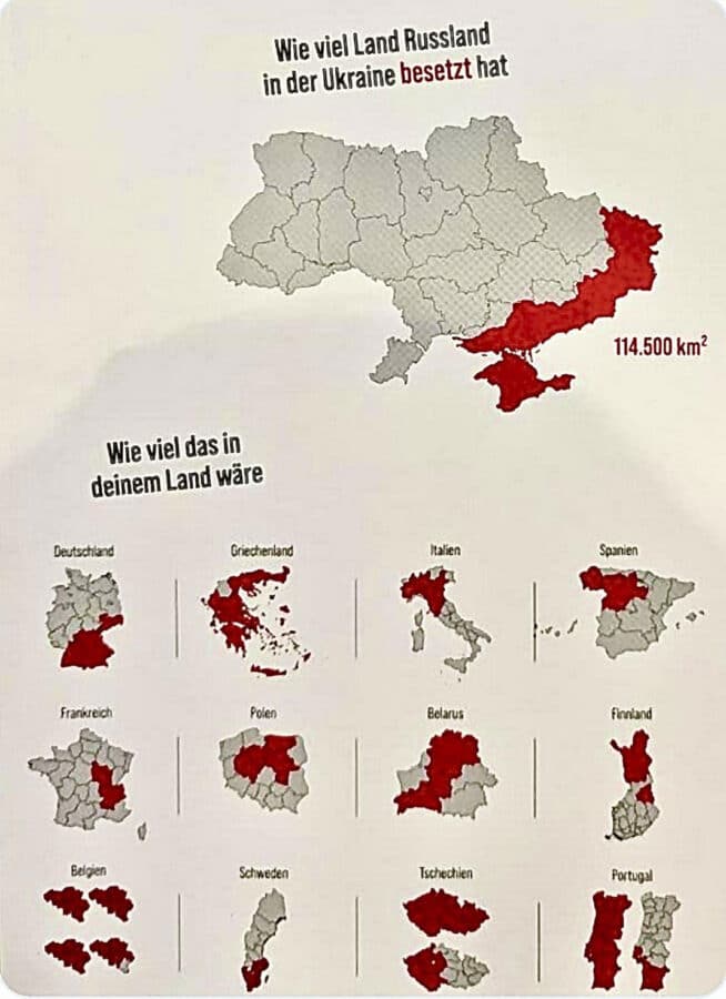
On the map is Ukraine, with the territories occupied by Russia highlighted in red: Crimea, the south of the Zaporizhzhia and Kherson regions, and most of Donbas.
The caption under the map is short but terrifying: 114,500 square kilometers.
The headline sounds simple, almost mundane — “Wie viel Land Russland in der Ukraine besetzt hat” — “How much land Russia has occupied in Ukraine”.
And below is a question that strikes any normal person:
“Wie viel das in deinem Land wäre?” — “How would this look in your country?”
Below the map of Ukraine, the editorial team placed fifteen mini-maps: Germany, France, Italy, Poland, Spain, Turkey, USA, Belarus, Finland, Portugal, Greece, Belgium, Czech Republic, Sweden, and Russia.
On each of them, the same area — 114,500 km² — is shaded in red, so everyone can see: if Russia took as much as in Ukraine, what would disappear on their own map.
This visualization turns dry numbers into a personal feeling — into a real, physical awareness of loss.
Scale: Comparison with Israel
To truly understand the scale, one just needs to look at the numbers.
The area of Israel in “internationally recognized borders” is 20,770 square kilometers.
If you add the Golan Heights and East Jerusalem — territories that Israel considers its own, (but more than 150 countries and the UN do not recognize their annexation, and recognition has been fully or partially expressed only by the USA, several Latin American countries, and some states in Africa and Oceania), — the total area will be about 22,000 square kilometers.
Add the controlled areas in Judea and Samaria — Zone C, about 60% of these lands, — and the area increases to 26,000.
And if you include all of Judea, Samaria, and the Gaza Strip, it will be about 28,000 square kilometers.
Now the comparison.
The Russian occupation covers 114,500 square kilometers.
This is more than five times the size of all of Israel in “internationally recognized borders”,
and about four times larger than modern Israel along with Judea, Samaria, and Gaza.
Even if we recall the historical maximum of 1967–1982, when Israel controlled Sinai, the Golan, Judea, Samaria, and Gaza, —
the entire territory was about 88,000 square kilometers.
And even then, Israel was smaller than the currently occupied part of Ukraine — by almost thirty thousand square kilometers.
If you transfer a “spot” of 114,500 km² onto the map of the Middle East, it would cover all of Israel, all of Judea and Samaria, Gaza, and Sinai —
and there would still be room for Lebanon + Cyprus, or one and a half Qatar, or an entire Kuwait.
What Exactly KATAPULT Magazine No. 39 Printed
The KATAPULT editorial team did not limit itself to the map of Ukraine.
The issue’s pages feature maps of fifteen countries — from Germany to the USA —
and on each of them, the same red spot of 114,500 km² is marked.
The editorial wrote:
“Diese Karten zeigen, wie groß die von Russland besetzten Gebiete der Ukraine sind – im Vergleich zu anderen Ländern.”
(“These maps show how large the territory occupied by Russia in Ukraine is – compared to other countries.”)
| Country | Area (km²) | Portion Covered by 114,500 km² | What It Means |
|---|---|---|---|
| 🇩🇪 Germany | 357,600 | 32% | about a third of the country |
| 🇬🇷 Greece | 131,957 | 87% | almost the entire territory |
| 🇮🇹 Italy | 301,340 | 38% | more than a third of the peninsula |
| 🇪🇸 Spain | 505,990 | 23% | about one-fifth |
| 🇹🇷 Turkey | 783,562 | 15% | about one-sixth |
| 🇫🇷 France | 543,940 | 21% | area from Paris to Lyon |
| 🇵🇱 Poland | 312,679 | 37% | almost all of central Poland |
| 🇧🇾 Belarus | 207,595 | 55% | more than half of the country |
| 🇫🇮 Finland | 338,440 | 34% | south and center of the country |
| 🇺🇸 USA | 9,833,520 | 1.1% | about the state of Pennsylvania |
| 🇧🇪 Belgium | 30,528 | 373% | more than three Belgiums |
| 🇸🇪 Sweden | 450,295 | 25% | a quarter of the country |
| 🇨🇿 Czech Republic | 78,867 | 145% | the whole country and half more |
| 🇵🇹 Portugal | 92,090 | 124% | almost the entire country |
| 🇷🇺 Russia | 17,098,242 | 0.67% | less than one percent of its territory |
These data show that if such a scale of occupation were transferred to any European country, it would lose a third or half of its territory.
And small states, like Belgium and the Czech Republic, would disappear from the map entirely.
KATAPULT makes the reader literally feel the scale of the catastrophe.
What looks like a red spot on the map is, in reality, cities, schools, streets, and millions of lives.
When a Map Stops Being Just Geography
On behalf of the editorial team of NAnews, we can say only one thing:
this map is not just a piece of journalism, but a visual scream.
In these lands, people are tortured, killed, raped.
Books are burned there, language is erased, children are stolen and prepared to one day take up arms against their country.
Every square kilometer on the KATAPULT map is a home that no longer exists,
and a family that will never return.
The publication of the German magazine is not about numbers, but about the conscience of the world.
About the fact that before our eyes, there is an attempt to rewrite the world,
and that Ukraine, defending itself, defends the very idea that
the borders of nations are not drawn with blood.
Ukraine must regain all its land — all of Donbas and all of Crimea.
Not partially. Not “by agreement”.
Completely. Because a world where territory can be stolen with impunity ceases to be a world.